



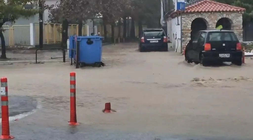
Forecasters say the heaviest phase may come on Tuesday and Wednesday, with the Ionian Islands, including Corfu and Zante, expected to see rain intensify on Monday
Storm Agneta is bringing torrential rain, thunderstorms and a risk of hail to large parts of Greece, with red weather alerts in force for some regions. Streets in Volos and Nea Ionia were turned into rivers on Sunday, with floodwater covering the wheels of parked cars. Rainfall is expected to intensify on Monday across the Ionian Islands, home to the holiday islands of Corfu and Zante, and across coastal areas of central Greece. Greek forecasters say another disturbance could keep the threat in place until Wednesday.
What the alerts cover
The picture is more complicated than a single nationwide red alert. The Hellenic National Meteorological Service’s overall bulletin was rated orange, but separate regional red warnings were issued under the MeteoAlarm system. One covered Central and Eastern Macedonia from 11am on Sunday until 1.59am on Monday, with more than 60mm of rain possible in 12 hours. Another covered the Dodecanese from 2pm on Sunday until 1.59am on Monday, with more than 80mm possible in 12 hours. Those are forecast thresholds, not measured rainfall. Athens and the wider Attica region were under a lower-level yellow warning on Sunday.
The National Observatory of Athens rated Sunday’s rainfall a Category 4, “very significant”, on its Rainfall Episode Index. Winds over the Aegean could reach force 6–7, and the forecasts say hail is most likely near coastal, island and offshore areas, though it cannot be guaranteed anywhere in particular. Reports did not confirm any ferry cancellations.
Timing: a break, then a second push
Greek meteorologist Theodoros Kolydas said Agneta formed over the Tyrrhenian Sea, west of Italy, and was named by Italian forecasters before moving towards Greece. It is separate from the weather system that was already causing floods on Sunday. He said the storm’s most organised phase is expected on Tuesday 3 November and Wednesday 4 November, as a new disturbance strengthens while the earlier low weakens. Another Greek forecast, based on National Observatory analysis and reported by iefimerida, expects a lull from early Monday until the afternoon, followed by renewed intensification in the evening, so a pause in the rain does not mean the danger has passed. Meteorologist Giorgos Tsatrafyllias told ProtoThema English that the rain would form a broad “Π” shape across western Greece, the northern mainland and the eastern islands.
The civil protection ministry’s updated bulletin on Sunday ordered regional authorities and municipalities to stay on high readiness. It named the coastal western Peloponnese as an area of concern from Monday afternoon and forecast intermittent severe weather in the Dodecanese until late Monday evening. It did not report any deaths or order evacuations.
Damage so far
In Alonaki, in Nea Anchialos, houses were flooded and cars swept away. Volos deputy mayor for civil protection Spyros Gatos told state broadcaster ERT that a river crossing at Alygarorema had been damaged and that around ten lorries and a digger were clearing flood damage in Agria. He said some drainage faults might need a road to be dug up and a new channel built, though no such repair has been approved. Floods also hit Dimini after 20–30 minutes of heavy rain, with a small excavator due on Monday, and stones were washed onto the road at Chrysi Akti Panagias. Ta Nea reported fast-flowing water on the island of Kimolos, difficult conditions in Crete’s White Mountains, and a two-lorry collision in dense fog near the Polymylos toll station that held up traffic on the Egnatia motorway. There was no evidence the crash was caused by the storm.
The storm follows destructive flooding a week earlier. Platanias in South Pelion had its right-hand side cut off, with phone alerts telling people to avoid basements and ground floors. One businessman said his oil warehouse was flooded: “Everything we had inside, cans full of 200 kilos of oil, all spilled.” On Skiathos, landslides blocked roads, including the main route towards Koukounaries.
Official advice
Greece’s civil protection agency told people in affected areas to secure loose objects, clear gutters and drains, and avoid crossing streams and torrents, on foot or by car, during storms and for several hours afterwards. It said to avoid outdoor work and activities at sea or on the coast during storms because of lightning, to shelter in a building or car during hail, and to keep away from large trees, hanging signs and balconies.
