


Forecasters say the UK may be facing the earliest major sudden stratospheric warming on record. Scientists stress, however, that it does not guarantee a cold snap, and the Met Office’s latest outlook does not predict widespread snow.
The Met Office says a warming of the stratosphere is weakening the polar vortex, and it could develop into the earliest major sudden stratospheric warming (SSW) ever recorded. The event increases the chance of cold weather in the UK, but does not guarantee it. Some forecasting model runs have suggested snow in parts of Scotland, England and Wales around 17 November. The Met Office’s latest long-range forecast, however, does not predict widespread snow on that date.
What is happening in the stratosphere
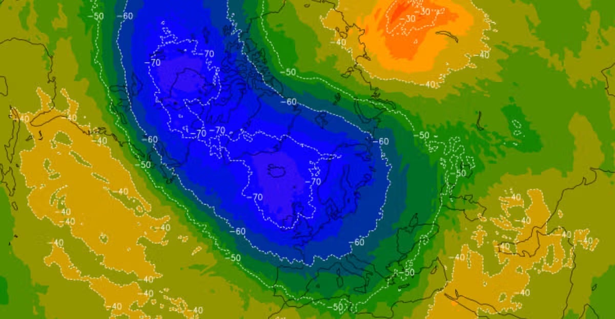
The polar vortex is a ring of powerful winds that keeps freezing air near the North Pole. When it weakens, Arctic air can spread south across the UK. A sudden stratospheric warming occurs when temperatures rise between 10km and 50km above the Earth’s surface. The cold air then rushes downwards, which affects the jet stream and can create a “blocking pattern” that keeps cold, snowy weather in place for a long period. A similar process led to the “Beast from the East” in 2018, which brought 22 inches of snow to parts of the country in February and March of that year.
Met Office forecaster Marco Petagna said: “At the moment, we’ve got a warming taking place in the stratosphere. The polar vortex in the stratosphere is starting to weaken.” He said that if the winds reversed direction, it would become a “major sudden stratospheric warming” event, potentially the earliest ever recorded.
Jeff Knight, the Met Office’s lead climate scientist, told the BBC that the UK faces “the earliest [major SSW event] on record looking back over the 75 years we’ve been observing”. He said most experts agree it is “a very unusual event”.
Professor Andrew Charlton-Perez of the University of Reading said on 6 November that meteorologists have never seen this kind of warming so early in the season. Reliable satellite observations go back to 1979, with other atmospheric records stretching to the 1940s. He explained that the timing is unusual because the vortex has to become established before atmospheric waves can disrupt it, and an early November disturbance leaves little time for the normal winter circulation to develop.
What the models show
According to the independent monitoring website PolarVortex.earth, all 50 members of the latest ECMWF ensemble forecast, updated on 7 November, predict easterly stratospheric winds by 21 November. The site calls this an unusually consistent signal. It says the earliest previously recorded major warming was on 28 November, in 1968 and 2025. The main ECMWF forecast shows winds falling to about -2.7 metres per second on 11 November, with a negative value indicating a reversal to easterly flow, one of the defining criteria for a major SSW. The vortex is also forecast to stretch to about 1.9 times its width around 16 November. The site stresses that these are model forecasts and not observed results or probabilities of UK snowfall.
Why snow is not guaranteed
Mr Petagna said an SSW does increase the chance of cold weather, “normally a few weeks down the line, so sort of deeper into November is when we’re more likely to see an influence if it does happen”. He added: “It’s important to emphasise that there was a major warming event last November, and on that occasion it didn’t directly lead to much cold weather in the UK. It doesn’t always happen, it just increases the chance of it occurring.”
In its 4 November analysis, the Met Office said many ECMWF ensemble forecasts support a reversal of the vortex’s normally westerly winds, but that the reversal looks relatively weak and potentially short-lived. A wind reversal high in the stratosphere does not guarantee disruption at ground level, as the effects must travel downwards before they can influence the jet stream and the UK’s weather. The Met Office says SSW events typically take several weeks to affect the surface, sometimes carrying over into the following month, so a November event could influence December instead of bringing immediate snow.
Its latest long-range forecast, covering 11 to 20 November, expects temperatures to be above average overall despite a colder start. It anticipates a mix of dry weather followed by Atlantic rain and strong winds, with wintry showers mainly in the far north of the UK. It does not confirm significant snowfall across England and Wales on 17 November. For 21 November to 5 December, the Met Office currently favours changeable or unsettled conditions, with Atlantic weather systems bringing rain, occasional strong winds and some drier spells. It says this is not a forecast of prolonged freezing weather.
Nick Finnis, a meteorologist at Netweather, concluded on 4 November that a direct impact on UK weather in November was unlikely, and that any consequences for December were highly uncertain. The model projections showed limited downward spread into the troposphere, the layer of atmosphere where most day-to-day weather occurs. He said the Madden-Julian Oscillation, a tropical atmospheric disturbance, could also affect Britain’s weather independently of the vortex, which makes any cold spell harder to attribute to the stratospheric event.
The El Niño question
Weather experts have suggested that this year’s El Niño, expected to be the strongest ever, could lead to a collapse of the polar vortex. The Met Office has said previously that following a peak in El Niño in the latter part of winter, the vortex can weaken, which increases the chance of SSW events and the potential for cold weather.
Professor Charlton-Perez cautioned, however, that there is not enough evidence to attribute the exceptionally early warming to the current El Niño, and that the relationship requires further analysis. He noted that the vortex was not unusually weak before the current disruption began, which challenges a simple explanation that El Niño gradually weakened it through the autumn. The mechanism is still being investigated. He said El Niño may be a contributing factor, but it does not establish that it caused the event or that the UK will have a severe winter.
Effects beyond the UK
According to the Met Office, a polar vortex disruption can favour blocking high pressure around the North Atlantic or Scandinavia. If that happens, northern Europe may see colder, drier conditions while southern Europe becomes milder and wetter. Snow is most likely where sufficiently cold air meets moisture. An easterly or northerly airflow can raise the potential for snow, particularly in eastern Britain, but cold high pressure can also bring dry weather with little snowfall. Professor Charlton-Perez said changes in the upper atmosphere can alter the distribution of high- and low-pressure systems across the Northern Hemisphere, although the regional effects remain uncertain. PolarVortex.earth says North America or parts of continental Europe may feel stronger effects than Britain, even if the major warming is confirmed.
