


The United Nations has voted overwhelmingly to move away from the centuries-old Mercator world map in favour of the Equal Earth projection, which depicts Africa at its true size and reduces the UK and US, following a campaign led by African nations against what supporters call “cartographic colonialism.”
The United Nations has voted to move away from the long-dominant Mercator world map in favour of a new projection that significantly enlarges Africa while reducing the size of the UK and US. The General Assembly’s “Correct the Map” resolution, sponsored by Togo and backed by members of the African Union, passed with 164 member states voting in favour, marking the culmination of a campaign led by African countries and advocacy groups against what they describe as “cartographic colonialism.”
Why the Mercator map has drawn criticism
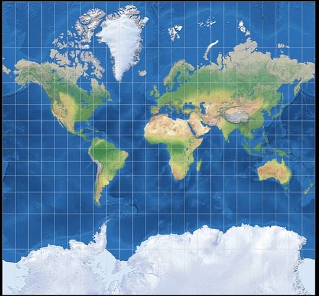
The Mercator projection, originally designed for sea travel rather than general use, has long been criticised for distorting the relative size of countries and continents in ways that reflect Western assumptions about the world. Under the projection, Greenland and Africa appear roughly the same size, despite Africa being around 14 times larger in reality.
Campaigners argue that this distortion carries a psychological effect, since people instinctively perceive larger objects as more significant, meaning a map that shrinks Africa relative to its true size can subtly influence how its global importance is understood.
Togolese Foreign Minister Robert Dussey, a leading supporter of the change, told Reuters: “A fair world begins with a fair map.” Speaking at an earlier UN briefing, he elaborated on the broader stakes involved: “A map is never neutral. It shapes perceptions, influences how the place of peoples and continents in the world is understood.” He added, in remarks quoted by the UN ahead of the vote: “Maps shape our understanding of the world. They guide education, nourish the imagination, and influence collective perceptions.”
How the vote played out
The resolution passed with the backing of 164 member states. The United States was the only country to vote against it, while six others, Serbia, Estonia, Georgia, Lithuania, Moldova and Ukraine, abstained. Importantly, the resolution does not ban the Mercator projection or mandate its replacement; it simply encourages governments and institutions around the world to adopt the Equal Earth projection instead.
Why the US opposed the change
The US representative, Yaryna Ferencevych, argued that the UN should be focused on issues such as peace, prosperity and international relations, rather than what she characterised as an ideological cartographic initiative. She further argued that the resolution “mocks the work and purpose” of the UN as an institution. According to reports, the US objection extended beyond the choice of map projection itself, specifically taking issue with the campaign’s broader language around “reparations” and “cognitive justice.”
Ukraine’s separate concern
Ukraine’s decision to abstain stemmed from a distinct territorial concern, reportedly connected to how some versions of the Equal Earth map depict Ukrainian territory currently occupied by Russia. Ukrainian officials are said to have supported the broader effort to address historical distortions affecting Africa and other parts of the Global South, while expressing reservations about how Ukraine’s own territory is represented under the projection.
Origins of the Equal Earth projection
The Equal Earth projection was developed in 2018 by cartographers Tom Patterson, Bernhard Jenny and Bojan Šavrič. It was specifically designed as an equal-area map, meaning it preserves the relative surface areas of continents more accurately than the Mercator projection. According to reports, its creators did not initially anticipate the level of international attention the projection has now received.
The African Union’s earlier adoption
The African Union had already formally adopted the Equal Earth projection in February 2026, several months ahead of the UN vote. The AU’s decision calls on member states to update their national school curricula to incorporate the new projection, and tasked the African Union Commission with working alongside a designated “Champion” to produce annual reports tracking implementation progress. The AU has linked the campaign to concepts of “cognitive justice” and reparations, framing distorted representations of Africa as part of the broader legacy of colonial-era cartography.
The push traces back further still, to the 9th Pan-African Congress held in Lomé, Togo, in December 2025, which called on the African Union and its member states to approach the UN over what it regarded as disproportionate representations of Africa, specifically identifying the Mercator projection as the source of the problem. The AU has since connected the issue to wider themes including African identity, education and the African Renaissance.
Togo’s plans for its own textbooks
Dussey said Togo intends to become the first country to update its geography textbooks to reflect the Equal Earth projection, and plans to spend the next six months engaging with African Union members and supporters in other regions to promote wider international adoption of the map.
Togo has stressed that the campaign is not intended to eliminate use of the Mercator projection for navigation, where it remains genuinely useful for maritime and aviation purposes. Instead, the proposed change is aimed primarily at general-purpose maps, educational materials and public representation more broadly.
France changes its own mapping policy
France has already announced a concrete policy shift in response to the campaign, confirming that its foreign ministry will stop using the Mercator projection, making it one of the clearest examples yet of a government changing its official mapping practice as a direct result. French Foreign Minister Jean-Noël Barrot argued that the Mercator projection gives countries including the US, Russia and China disproportionate visual prominence compared with Africa, Latin America and Southeast Asia. He said: “Changing maps obviously doesn’t change the world. But correcting a distorted representation is already an act of truth.”
Calls for wider adoption
Campaign group Africa No Filter has said it wants the shift to extend well beyond government and UN maps, calling for adoption across schools, textbooks, newsrooms, businesses and digital platforms. Such a shift could ultimately affect how Africa is represented not only in official diplomatic contexts but in educational resources, media graphics and digital mapping products used by large numbers of people worldwide.
Following the vote, the African Union welcomed the UN’s decision and renewed its call for equal-area projections such as Equal Earth to be used more widely in classrooms, media and international institutions. Carlos Lopes, a professor at the University of Cape Town and a supporter of the campaign, described the 164-vote result as an emotional moment for those who had pushed for the change.
