

Britain is set for a dramatic temperature swing in the coming days, with weather maps showing highs of around 30C in parts of the south east, as an area of high pressure moves in from the south following a week of cloudy, wet and chilly conditions.
BBC weather forecaster Tomasz Schafernaker said the change in fortunes would be welcome news for sun lovers. “I’ve got some good news in the forecast for the week ahead after the recent cloudy, rainy, chilly weather, we are in for something a lot more cheerful, some blue skies it is going to turn a lot brighter over the coming days at least for most of us and also a little bit warmer,” he said. “The wind is coming in from the south, it will be very warm in France and some of that air will waft our way.”
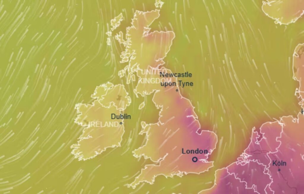
The warmest weather is expected to arrive next Friday, 19 June, with weather maps from Ventusky showing the south east of England and parts of East Anglia turning red as temperatures climb. Lincolnshire, Rutland, Cambridgeshire, Norfolk, Suffolk, Essex, Hertfordshire and London are all forecast to reach at least 28C, with Chelmsford among the areas expected to peak around 30C by the end of next week.
The picture will look very different elsewhere in the country. The south west of England, along with much of Wales and Scotland, is set to miss the bulk of the incoming warm air and can expect temperatures in the mid-teens. Central and northern England should fare somewhat better, with temperatures likely to climb above 20C and reach the mid-20s in places.
Schafernaker explained the unsettled pattern expected midweek before the warmer conditions take hold. “Midweek we do have the jetstream right over us sending more weather fronts our way with low pressure, to the south high pressure tries to build across the continent and that does mean very warm weather developing anywhere through Portugal, Spain, France and we are just on the cusp of the hotter weather,” he said. “Some of that warmth will head our way, just how far north it will reach is still a little bit uncertain.”
The Met Office’s forecast covering 19 to 26 June points to a changeable spell before high pressure becomes dominant. “A changeable period is likely through the middle and latter part of next week with outbreaks of occasionally heavy rain focused across the north and especially west, some of which could spread to parts of the south and southeast at times,” the forecast states, adding that strong winds may accompany this, mainly around northern and western coasts. “Through next weekend and into the following week, high pressure will probably become more dominant with conditions turning more widely dry and settled. Temperatures are likely to be above normal for most parts, and across the southeast in particular it could be very warm or hot at times, especially next weekend.”
The counties forecast to hit 28C or higher by Friday are Lincolnshire, Rutland, Cambridgeshire, Norfolk, Suffolk, Essex, Hertfordshire and London.
